


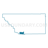
Voting District 40240, Kern County, California
About
Outline

Summary
| Unique Area Identifier | 531340 |
| Name | Voting District 40240 |
| County | Kern County |
| State | California |
| Area (square miles) | 86.53 |
| Land Area (square miles) | 86.51 |
| Water Area (square miles) | 0.02 |
| % of Land Area | 99.98 |
| % of Water Area | 0.02 |
| Latitude of the Internal Point | 34.87687330 |
| Longtitude of the Internal Point | -119.06066810 |
Maps


Graphs
Select a template below for downloading or customizing gragh for Voting District 40240, Kern County, California


Neighbors
Neighoring Voting District (by Name) Neighboring Voting District on the Map
- Voting District 30581, Ventura County, CA
- Voting District 30735, Ventura County, CA
- Voting District 40250, Kern County, CA
- Voting District 40255, Kern County, CA
- Voting District 40300, Kern County, CA
- Voting District 40305, Kern County, CA
- Voting District 40925, Kern County, CA
- Voting District 40930, Kern County, CA
- Voting District 40940, Kern County, CA
- Voting District 40945, Kern County, CA
- Voting District 40950, Kern County, CA
- Voting District 40955, Kern County, CA
- Voting District 40960, Kern County, CA
Top 10 Neighboring County Subdivision (by Population) Neighboring County Subdivision on the Map
- Tehachapi CCD, Kern County, CA (36,300)
- West Kern CCD, Kern County, CA (30,229)
- Los Padres CCD, Ventura County, CA (819)
Top 10 Neighboring Place (by Population) Neighboring Place on the Map
- Frazier Park CDP, CA (2,691)
- Pine Mountain Club CDP, CA (2,315)
- Lebec CDP, CA (1,468)
- Lake of the Woods CDP, CA (917)
Top 10 Neighboring Elementary School District (by Population) Neighboring Elementary School District on the Map
Top 10 Neighboring Secondary School District (by Population) Neighboring Secondary School District on the Map
Top 10 Neighboring Unified School District (by Population) Neighboring Unified School District on the Map
- El Tejon Unified School District, CA (8,427)
- Maricopa Unified School District, CA (1,803)
- Cuyama Joint Unified School District, CA (1,157)
Top 10 Neighboring State Legislative District Lower Chamber (by Population) Neighboring State Legislative District Lower Chamber on the Map
Top 10 Neighboring State Legislative District Upper Chamber (by Population) Neighboring State Legislative District Upper Chamber on the Map
Top 10 Neighboring 111th Congressional District (by Population) Neighboring 111th Congressional District on the Map
Top 10 Neighboring Census Tract (by Population) Neighboring Census Tract on the Map
- Census Tract 60.07, Kern County, CA (5,474)
- Census Tract 33.06, Kern County, CA (4,897)
- Census Tract 33.05, Kern County, CA (3,608)
- Census Tract 1, Ventura County, CA (819)